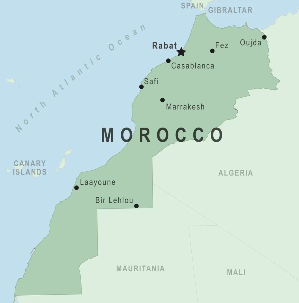
Map of Morocco
Looking at a map of Morocco for the first time, most travelers are surprised by how much the country changes from one region to the next. Within a single week, it’s possible to go from Mediterranean cliffs to snow-dusted mountain passes, from a walled imperial city to the quiet silence of the Sahara Desert. Before booking flights or building an itinerary, understanding how these regions fit together on the map of Morocco is the difference between a trip that flows naturally and one that spends too many hours in transit.
Morocco sits at the northwestern edge of Africa, bounded by the Atlantic Ocean to the west and the Mediterranean Sea along its northern coast. The Atlantic side is by far the longer coastline and home to the country’s largest cities, while the shorter Mediterranean stretch in the north faces Spain across the narrow Strait of Gibraltar. This position, so close to Europe yet culturally distinct from it, is exactly what turned Morocco into a historic crossroads and it’s still what makes the country so rewarding to explore today.
Morocco Regions Map: Understanding the Country’s Geography
What makes the map of Morocco genuinely interesting for travelers isn’t just its size, but how many different landscapes are packed inside it. The High Atlas Mountains run through the center and south of the country, forming a natural divide between the fertile north and the drier south. Further north, the smaller Rif Mountains rise above the Mediterranean coast, covered in cedar forest and giving the region a climate that feels closer to southern Spain than to the Sahara a few hundred kilometers away.
Along the Atlantic coast, the terrain flattens into wide, fertile plains with a mild, breezy climate the reason cities like Rabat and Casablanca grew into major hubs here. Moving south and inland, the landscape dries out steadily, plains give way to rocky valleys, and eventually the true desert takes over. Because this shift from coastline to mountains to desert can happen within a single day’s drive, a clear regional map of Morocco is one of the most useful tools for building a trip that covers real ground without exhausting your travelers.
Morocco Tourist Map: Top Cities and Destinations by Region
Northern Morocco: Tangier, Chefchaouen & Fes
Northern Morocco is usually the first region travelers see on a map of Morocco itinerary, and it carries a distinct identity shaped by centuries of contact with Europe.
- Tangier, the region’s largest city, sits at the exact point where the Atlantic meets the Mediterranean. Once known as a haven for writers, artists, and diplomats, Tangier has spent the last decade modernizing its port and waterfront while keeping its old medina fully intact a mix of narrow alleys, spice markets, and seaside cafes that still carries its old bohemian energy.
- Chefchaouen, tucked into the Rif Mountains between Tangier and Fes, is Morocco famous Blue City, instantly recognizable by its blue-washed walls and stone streets. It’s a slower, quieter town than Morocco larger cities, wrapped in green hills, and it’s consistently one of the most photographed stops on any map of Morocco. Hemp is grown in the surrounding countryside, though the sale and use of marijuana remains illegal in Morocco.
- Fes is widely considered the country’s cultural and spiritual heart. As Morocco oldest imperial city, it’s built around one of the largest car-free urban centers in the world, a medina so intricate that getting pleasantly lost in it is part of the experience. Fes is home to centuries-old leather tanneries, historic religious schools, and the University of Al Qarawiyyin, recognized as one of the oldest continuously operating universities on earth. If you want to base a few days here, our tours from Fes are built specifically around this kind of slow, immersive exploration.
Marrakech: The Heart of Central Morocco
No map of Morocco is complete without Marrakech, the country’s most visited city and the natural gateway to the High Atlas Mountains. Built where the plains meet the foothills, Marrakech blends centuries-old architecture with a genuinely modern pace of life. Its medina is famous for the Jemaa el-Fnaa square, where storytellers, food stalls, and musicians create a scene found nowhere else in the country.
Beyond the main square, Marrakech offers landmarks worth building a full day around, the Koutoubia Mosque and its towering minaret, the excavated Saadian Tombs, and the Majorelle Garden, a small botanical oasis originally designed by a French painter and later restored by Yves Saint Laurent. Because of its central position and strong transport links, Marrakech is also the most common starting point for desert routes and mountain excursions you’ll find our most popular tours from Marrakech and day trips from Marrakech built around exactly this advantage.
Atlantic Coast: Rabat, Casablanca, Essaouira & Agadir
Morocco Atlantic coastline holds its two largest cities, along with some of its best beach towns.
- Rabat, the capital of Morocco, is quieter and more relaxed than Marrakech or Casablanca. Its highlights include the unfinished but still striking Hassan Tower and the Kasbah of the Udayas, a fortified old quarter overlooking the river and ocean with whitewashed walls and quiet gardens.
- Casablanca is Morocco largest city and economic center, known for its Art Deco buildings and modern skyline rather than its old medina. Its landmark, the Hassan II Mosque, is one of the largest mosques in the world and one of the few in Morocco open to non-Muslim visitors. Casablanca Mohammed V International Airport is also the country’s busiest, making it a common starting point see our tours from Casablanca if you’re arriving here first.
Further south, Essaouira and Agadir draw a different kind of traveler. Essaouira, with its walled medina and steady Atlantic winds, has become a favorite for windsurfers and anyone chasing fresh seafood and a slower coastal rhythm it’s also one of our most popular day trips from Marrakech. Agadir, rebuilt after a major earthquake in the 1960s, is a more modern resort city known for long sandy beaches and reliable sunshine year-round.
Southern Morocco and the Sahara Desert Map
South of the Atlas Mountains, the landscape turns drier, more rugged, and eventually gives way to true desert. This region begins near Ouarzazate, often called the gateway to the Sahara, and continues south through Western Sahara toward Laayoune and Dakhla.
For many visitors, the main highlight of this part of Morocco is the desert around Merzouga and Zagora. Merzouga sits beside the towering Erg Chebbi dunes, some of the tallest in the country, and is the most popular base for camel treks, 4×4 excursions, and overnight stays in desert camps under the stars. Zagora leads to the quieter Erg Chigaga dunes a good choice for travelers who want the same experience with fewer crowds. Since public transportation to these areas is limited, nearly all visitors reach the desert as part of a guided route, which is exactly what our Morocco Desert Tours are designed for.
Morocco Road Trip Map: Distances and Travel Times Between Cities
Morocco northern and coastal cities are connected by a modern rail network, so it’s entirely possible to move between Casablanca, Rabat, Marrakech, Fes, and Tangier without ever needing a car. Having a rough sense of distances makes it much easier to plan a realistic route rather than an overly ambitious one:
- Casablanca to Rabat: about 90 km, roughly 1 hour by train or car
- Casablanca to Marrakech: about 240 km, roughly 3 hours
- Marrakech to Fes: about 550 km, roughly 8 to 9 hours by road, or a similar duration by train with one connection
- Fes to Chefchaouen: about 200 km, roughly 3 to 4 hours
- Marrakech to Merzouga (Sahara): about 560 km, roughly 9 hours, typically broken into a multi-day route through the Atlas Mountains and Dades Valley
Once you move off the main rail corridor and into the mountains or desert, travel naturally slows down, since roads wind through passes rather than running in straight lines. This is why most travelers heading toward the Sahara choose a guided route with a private driver instead of self-navigating, particularly on a first visit to Morocco.
Morocco Itinerary Map: How to Plan Your Route
The most efficient way to cover Morocco highlights is to think in terms of a loop rather than a straight line, since backtracking across the country burns through valuable travel days. Most well-paced trips link two or three of the country’s core regions imperial cities, the Atlas Mountains, and the Sahara rather than trying to cover everything at once.
If you’d rather not plan this yourself, our Morocco Private Tours are built around exactly this kind of route logic, and our Morocco Travel Guide is a good next stop for practical planning advice once you’ve got a sense of the geography. And since the right season changes what’s comfortable in the desert versus the mountains, it’s worth checking the best time to visit Morocco before locking in your dates.
Frequently Asked Questions About the Map of Morocco
Where is Morocco located on a world map?
Morocco sits in the northwestern corner of Africa, bordered by the Atlantic Ocean to the west and the Mediterranean Sea to the north, with Spain visible across the Strait of Gibraltar on a clear day.
What are the main regions on the map of Morocco?
Morocco is generally divided into the northern Mediterranean coast, the central Atlas Mountains and Marrakech area, the Atlantic coastal cities, and the southern desert region toward the Sahara.
What is the best Morocco road trip route for a first visit?
A popular route connects Casablanca or Marrakech with Fes, Chefchaouen, and the Sahara Desert near Merzouga, giving you a chance to see Morocco coast, mountains, and desert in one trip.
How many days do you need to see Morocco main highlights?
Most well-paced itineraries covering the Imperial Cities and a Sahara Desert extension run between 8 and 12 days, though shorter 5 to 6 day trips focused on Marrakech and the desert are also popular. Our Morocco Tour Packages cover both.
Is it safe to travel around Morocco using this route?
Yes see our full breakdown on whether it’s safe to travel to Morocco for a region-by-region look at safety for travelers.